Input parameters
Different parameters for model input and output of SFINCS can be changed in sfincs.inp, see below.
Traditionally SFINCS neglects the advection term in the SFINCS-LIE version (‘advection = 0’). For super-critical flow conditions or modelling waves, the SFINCS-SSWE version can be used (‘advection = 1’ for 1D modelling and ‘advection = 2’ for 2D modelling) for better performance.
Parameters for model input
- mmax
- description
Number of grid cells in x-direction
- units
- default
0
- min
1
- max
Inf (recommended is to limit the total number of active cells to max 3 million)
- nmax
- description
Number of grid cells in y-direction
- units
- default
0
- min
1
- max
Inf (recommended is to limit the total number of active cells to max 3 million)
- dx
- description
Grid size in x-direction
- units
m
- default
0
- min
1.0e-3
- max
Inf (recommended is a maximum grid size of 1000 meters)
- dy
- description
Grid size in y-direction
- units
m
- default
0
- min
1.0e-3
- max
Inf (recommended is a maximum grid size of 1000 meters)
- x0
- description
X-coordinate of first grid cell corner (1,1), thus not center of grid cell, in projected UTM zone.
- units
m in projected UTM zone
- default
0
- min
0
- max
Inf
- y0
- description
Y-coordinate of first grid cell corner (1,1), thus not center of grid cell, in projected UTM zone.
- units
m in projected UTM zone
- default
0
- min
0
- max
Inf
- rotation
- description
Rotation of the grid in degrees from the x-axis (east) in anti-clockwise direction
- units
degrees
- default
0
- min
0
- max
359.999
- advection
- description
setting for advection. 0 for no advection scheme (SFINCS-LIE), 1 for 1D advection scheme for modelling in 1D OR 2 for 2D advection scheme for modelling in 2D (SFINCS-SSWE).
- units
- default
0
- min
0
- max
2
- alpha
- description
CFL-condition reduction. Decrease for additional numerical stability, minimum value is 0.1 and maximum is 0.75.
- units
- default
0.75
- min
0.1 (recommended)
- max
0.75 (recommended)
- huthresh
- description
Minimum flow depth limiter.
- units
m
- default
0.05
- min
0.001 (recommended)
- max
0.1 (recommended)
- theta
- description
Smoothing factor in momentum equation. Advised not too change and to use 1.0 by default.
- units
- default
1.0
- min
0.8
- max
1.0
- zsini
- description
Initial water level.
- units
m above reference level
- default
0
- min
-Inf
- max
Inf
- qinf
- description
Infiltration rate, specify in +mm/hr.
- units
mm/hr
- default
0
- min
0
- max
100
- manning
- description
Uniform manning roughness, specify in s/m^(1/3).
- units
s/m^(1/3)
- default
0.04
- min
0
- max
0.1 (advised)
- rgh_level_land
- description
Elevation level to distinguish land and sea roughness (when using ‘manning_land’ and ‘manning_sea’).
- units
m above reference level
- default
0
- min
-Inf
- max
Inf
- manning_land
- description
Varying manning roughness based on elevation (above ‘rgh_level_land’, overules uniform ‘manning’, specify in s/m^(1/3).
- units
s/m^(1/3)
- default
-999 (=not used)
- min
0
- max
0.1 (advised)
- manning_sea
- description
Varying manning roughness based on elevation (below ‘rgh_level_land’, overules uniform ‘manning’, specify in s/m^(1/3).
- units
s/m^(1/3)
- default
-999 (=not used)
- min
0
- max
0.1 (advised)
More parameters for model input (only for advanced users)
- bndtype
- description
Boundary type for interpretation of ‘sfincs.bzs’ time-series. bndtype=1 is for water levels, bndtype=2 (advanced) is for horizontal velocities (in m/s) and bndtype=3 (advanced) for horizontal discharges (in m2/s).
- units
- default
1
- min
1
- max
3
- rhoa
- description
Density of the air
- units
kg/m3
- default
1.25
- min
- max
- rhow
- description
Density of the water
- units
kg/m3
- default
1024
- min
- max
- stopdepth
- description
Water depth anywhere in the domain after which the simulation is classified as unstable and stopped
- units
m
- default
100
- min
0
- max
Inf
- advlim
- description
Advection limiter when advection>0 to limit the magnitude of the advection term when calculating fluxes between cells.
- units
- default
9999
- min
0
- max
9999
- dtmax
- description
Maximum internal time step to be used
- units
s
- default
60
- min
1.0e-3
- max
Inf
- dtmin
- description
Minimum internal time step to be used
- units
s
- default
1.0e-3
- min
1.0e-3
- max
Inf
- tspinup
- description
Duration of internal spinup period before tstart
- units
s
- default
60
- min
0
- max
Inf
Drag coefficients:
- cdnrb
- description
Number of specified break points
- units
- default
3
- min
2
- max
- cdwnd
- description
Wind speed break points (including 0)
- units
- default
0 28 50
- min
2 values
- max
- description
Drag coefficient brak points
- units
- default
0.001 0.0025 0.0015
- min
2 values
- max
Different parameters influencing the given output by SFINCS can be changed, see below.
Parameters for model output
- tref
- description
Reference date in ‘yyyymmdd HHMMSS’
- units
- default
20000101 000000
- tstart
- description
Start date in ‘yyyymmdd HHMMSS’
- units
- default
20000101 000000
- tstop
- description
Stop date in ‘yyyymmdd HHMMSS’
- units
m
- default
20000101 000000
- trstout
- description
Specific time in seconds since ‘tref’ for binary restart file output being written away, turned of by default.
- units
s
- default
-999.0
- dtout
- description
Time-step global map output.
- units
s
- default
0
- dthisout
- description
Time-step observation points output.
- units
s
- default
600
- dtmaxout
- description
Time-step interval of global map output of maximum water level. If not specified, the maximum over the entire simulation is calculated. If no output is wanted, specify ‘dtmaxout = 0’.
- units
s
- default
999999
- min
0
- max
‘tstop - start in seconds’
- dtrstout
- description
Time-step for binary restart file output being written away, turned of by default.
- units
s
- default
0
- dtwnd
- description
Time-interval wind update (only for spiderweb)
- units
s
- default
1800
- outputformat
- description
Choice whether the SFINCS model output is given in binary ‘bin’, ascii ‘asc’ or netcdf files ‘net’ (default). In case of netcdf output, global output is given in ‘sfincs_map.nc’, point output in ‘sfincs_his.nc’ in case observation points are specified.
- units
- default
net
- twet_threshold
- description
Threshold value of water depth to count cell as flooded for keeping track of wet cells with storetwet = 1
- units
m
- default
0.01
- storetwet
- description
Flag to turn on writing away duration that a cell was wet during simulation (storetwet = 1)
- units
- default
0
- storevel
- description
Flag to turn on writing away velocities on ‘dtout’ interval during simulation (storevel = 1)
- units
- default
0
- storevelmax
- description
Flag to turn on writing away maximum velocities on ‘dtmaxout’ interval during simulation (storevelmax = 1)
- units
- default
0
- storecumprcp
- description
Flag to turn on writing away cumulative precipitation on ‘dtmaxout’ interval during simulation (storecumprcp = 1)
- units
- default
0
- storehsubgrid
- description
Flag to turn on writing away unaccurate water depth estimate for subgrid mode on ‘dtmaxout’ interval during simulation (storehsubgrid = 1)
- units
- default
0
- storeqdrain
- description
Flag to turn on writing away drainage discharge during simulation (storeqdrain = 1)
- units
- default
0
- storezvolume
- description
Flag to turn on writing away water volumes for the subgrid mode during simulation (storezvolume = 1)
- units
- default
0
- storemeteo
- description
Flag to turn on writing away meteo input data during simulation (storemeteo = 1)
- units
- default
0
- storemaxwind
- description
Flag to turn on writing away maximum wind speed during simulation (storemaxwind = 1)
- units
- default
0
- debug
- description
Flag to turn on writing away every timestep to output as debug mode (debug = 1)
- units
- default
0
Input files
SFINCS consists of many different input files, this overview gives a description, whether they are required or not, unit and format (bin = binary, asc = ascii and net = netcdf).
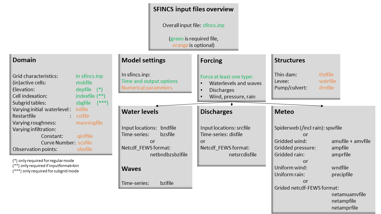
Fig. 20 Overview of input file of SFINCS with indication whther they are required or not
Domain
- sfincs.inp
- description
General input file of SFINCS describing all model settings, the domain, forcing and structures.
- required
yes
- format
asc
- depfile = sfincs.dep
- description
Elevation (bathymetry and topography) at grid cell centres above a reference level.
- units
m above reference level
- required
yes in case of regular mode, no in case of subgrid mode
- format
bin or asc
- mskfile = sfincs.msk
- description
This mask indicates for every cell whether it is an inactive cell (msk=0), active cell (msk=1), boundary cell (msk=2) or outflow boundary cell msk=3).
- units
- required
yes
- format
bin or asc
- indexfile = sfincs.ind
- description
File describing the indices of active grid cells within the overall grid. Not used by SFINCS with ascii input.
- units
- required
Only if ‘inputformat = bin’
- format
bin
- mskfile = sfincs.msk
- description
This mask indicates for every cell whether it is an inactive cell (msk=0), active cell (msk=1), water level boundary cell (msk=2) or outflow boundary cell msk=3).
- units
- required
yes
- format
bin or asc
- manningfile = sfincs.man
- description
For spatially varying friction values per cell use the manningfile option, with the same grid based input as the depfile using a binary file. Not used by SFINCS in subgrid mode.
- units
s/m^(1/3)
- required
no in case of regular mode, ignored in case of subgrid mode
- format
bin
- qinffile = sfincs.qinf
- description
For spatially varying constant in time infiltration values per cell use the qinffile option, with the same grid based input as the depfile using a binary file.
- units
mm/hr
- required
no
- format
bin
- scsfile = sfincs.scs
- description
For spatially varying infiltration values per cell using the Curve Number method use the scsfile option, with the same grid based input as the depfile using a binary file.
- units
- required
no
- format
bin
- sbgfile = sfincs.sbg
- description
File containing subgrid tables, only needed by SFINCS if you want to run your model in the subgrid mode.
- units
- required
Only for running SFINCS in subgrid mode
- format
bin
- obsfile = sfincs.obs
- description
To get output time-series at individual point locations, observations points have to be specified.
- units
m in projected UTM zone
- required
no (only if point output is wanted)
- format
asc
- crsfile = sfincs.crs
- description
To get output time-series of discharge through a cross-section, cross_sections have to be specified.
- units
m in projected UTM zone
- required
no (only if cross-section output is wanted)
- format
tekal
- inifile = sfincs.ini
- description
For spatially varying initial water level per cell, with the same grid based input as the depfile using a binary file. In older version this was an ascii file still, not from official release v0.0.1 onwards!
- units
m above reference level
- required
no
- format
bin
- rstfile = sfincs.rst
- description
More advanced restartfile that can also contain fluxes and velocities. As produced by SFINCS if dtrstout > 0 OR trstout > 0. Type of restart - 1: zs, qx, qy, umean and vmean - 2: zs, qx, qy - 3: zs
- units
- required
no
- format
bin
Forcing - Water levels and waves
- bndfile = sfincs.bnd
- description
To specify water-level time-series to the boundary cells (msk=2), first the input locations have to be specified in ‘sfincs.bnd’.
- units
m in projected UTM zone
- required
Only when specifying water levels and waves.
- format
asc
- bzsfile = sfincs.bzs
- description
In the file ‘sfincs.bzs’ the (slowly varying) water level time-series are specified per input location.
- units
m above reference level
- required
Only when specifying water levels.
- format
asc
- bzifile = sfincs.bzi
- description
Tn the file ‘sfincs.bzi’ the quickly varying water level time-series due to incoming waves are specified per input location. Do note that the input timestep should be the same in both the bzs and bzi files!
- units
m around mean water level of bzsfile
- required
Only when specifying waves.
- format
asc
- netbndbzsbzifile = sfincs_netbndbzsbzifile.nc
- description
To specify all bnd, bzs (and bzi) input in 1 FEWS compatible netcdf input file. Specify either the netcdf version or ascii, not both.
- units
m in projected UTM zone, m above reference level & m around mean water level of bzsfile
- required
Only when specifying water levels and waves using netcdf input file.
- format
net
Forcing - Discharges
- srcfile = sfincs.src
- description
To specify discharge points, first the input locations have to be specified in ‘sfincs.src’.
- units
m in projected UTM zone
- required
Only when specifying discharges.
- format
asc
- disfile = sfincs.dis
- description
In the file ‘sfincs.dis’ the discharge time-series are specified per input location.
- units
m^3/s
- required
Only when specifying discharges.
- format
asc
- netsrcdisfile = sfincs_netsrcdisfile.nc
- description
To specify all src & dis input in 1 FEWS compatible netcdf input file. Specify either the netcdf version or ascii, not both.
- units
m in projected UTM zone, discharge in m3/s
- required
Only when specifying discharges.
- format
net
Forcing - Meteo
- spwfile = sfincs.spw
- description
Spiderweb file including wind speed, direction, pressure (and possibly rainfall).
- units
coordinates: m in projected UTM zone, data: m/s, wind_from_direction in degrees, p_drop in Pa (and precipitation in mm/hr).
- required
no
- format
asc
- amufile = sfincs.amu
- description
Delft3D-meteo ascii type input of wind speed in x-direction.
- units
coordinates: m in projected UTM zone, data: m/s
- required
no
- format
asc
- amvfile = sfincs.amv
- description
Delft3D-meteo ascii type input of wind speed in y-direction.
- units
coordinates: m in projected UTM zone, data: m/s
- required
no
- format
asc
- ampfile = sfincs.amp
- description
Delft3D-meteo ascii type input of atmospheric pressure.
- units
coordinates: m in projected UTM zone, data: Pa
- required
no
- format
asc
- amprfile = sfincs.ampr
- description
Delft3D-meteo ascii type input of precipitation intensity.
- units
coordinates: m in projected UTM zone, data: mm/hr
- required
no
- format
asc
- wndfile = sfincs.wnd
- description
Spatially uniform wind
- units
wind speed in m/s, wind direction in nautical from where the wind is coming
- required
no
- format
asc
- precipfile = sfincs.prcp
- description
Spatially uniform precipitation
- units
mm/hr
- required
no
- format
asc
- netamuamvfile = sfincs_netamuamvfile.nc
- description
FEWS type netcdf meteo input with wind speed in both x-&y-direction in m/s.
- units
coordinates: m in projected UTM zone, data: m/s
- required
no
- format
net
- netampfile = sfincs_netampfile.nc
- description
FEWS type netcdf meteo input with atmospheric pressure in Pa.
- units
coordinates: m in projected UTM zone, data: Pa
- required
no
- format
net
- netamprfile = sfincs_netamprfile.nc
- description
FEWS type netcdf meteo input with precipitation in mm/hr.
- units
coordinates: m in projected UTM zone, data: mm/hr
- required
no
- format
net
Structures
- thdfile = sfincs.thd
- description
With a thin dam flow through certain grid cells is completely blocked (i.e. an infinitely high wall).
- units
coordinates: m in projected UTM zone.
- required
no
- format
asc
- weirfile = sfincs.weir
- description
Weirs are in principle the same as a thin dam, but then with a certain height (levee).
- units
coordinates: m in projected UTM zone, elevation in m above reference level, weir formula coefficient in [-]
- required
no
- format
asc
- drnfile = sfincs.drn
- description
Drainage pumps and culverts are both specified using the same format file, put with a different indication of the type (type=1 is drainage pump, type=2 is culvert).
- units
coordinates: m in projected UTM zone, discharges in m^3/s.
- required
no
- format
asc