Input parameters
Different parameters for model input and output of SFINCS can be changed in sfincs.inp, see below.
Parameters for model input
- mmax
- description
Number of grid cells in x-direction
- units
- default
0
- min
1
- max
Inf (recommended is to limit the total number of active cells to max 3 million)
- nmax
- description
Number of grid cells in y-direction
- units
- default
0
- min
1
- max
Inf (recommended is to limit the total number of active cells to max 3 million)
- dx
- description
Grid size in x-direction
- units
m
- default
0
- min
1.0e-3
- max
Inf (recommended is a maximum grid size of 1000 meters)
- dy
- description
Grid size in y-direction
- units
m
- default
0
- min
1.0e-3
- max
Inf (recommended is a maximum grid size of 1000 meters)
- x0
- description
X-coordinate of first grid cell corner (1,1), thus not center of grid cell, in projected UTM zone.
- units
m in projected UTM zone
- default
0
- min
0
- max
Inf
- y0
- description
Y-coordinate of first grid cell corner (1,1), thus not center of grid cell, in projected UTM zone.
- units
m in projected UTM zone
- default
0
- min
0
- max
Inf
- rotation
- description
Rotation of the grid in degrees from the x-axis (east) in anti-clockwise direction
- units
degrees
- default
0
- min
0
- max
359.999
- advection
- description
Setting for advection. Releases after Cauberg: 0 for no advection scheme (SFINCS-LIE), 1 for advection scheme on (default, SFINCS-SSWE). This replaces the old obsolete differentation between 1D part of advection (advection=1) and 2D part (advection=2).
- units
- default
1
- min
0
- max
1
- advection_scheme
- description
Advection scheme selection, new scheme is ‘upw1’, default. Original implementation from Leijnse et al. (2021) can be selected as ‘advection_scheme = original’ for backwards compatability. NOTE - from SFINCS 2024.01 release onwards.
- units
- default
upw1
- min
upw1
- max
original
- advlim
- description
Limit advection term (when advection > 0) such that horizontal acceleration due to advection does not exceed advlim (default 1.0 m/s2, so limiter turned on by default
- units
m/s2
- default
1.0 - updated from SFINCS v2.2.0 onwards
- min
0
- max
9999
- alpha
- description
Numerical time step reduction for CFL-condition. Decrease for additional numerical stability, minimum value is 0.1 and maximum is 0.75.
- units
- default
0.5
- min
0.1 (recommended)
- max
0.75 (recommended)
- friction2d
- description
Option to select to include 2D component for determining friction term as well: friction2d - true, default. Original implementation from Leijnse et al. (2021) can be selected as ‘friction2d = false’ for backwards compatability. NOTE - from SFINCS 2024.01 release onwards.
- units
- default
true
- min
false
- max
true
- huthresh
- description
Minimum flow depth limiter.
- units
m
- default
0.05
- min
0.001 (recommended)
- max
0.1 (recommended)
- theta
- description
Numerical smoothing factor in momentum equation. Default of 1.0 means no smoothing.
- units
- default
1.0
- min
0.8
- max
1.0
- hmin_cfl - added from SFINCS v2.2.0 onwards
- description
Minimum water depth to determine maximum timestep using CFL-conditions. Possibility to lower the maximum timestep for increased stability by putting a larger values than the deafult of 0.1 m (as was default before became user option).
- units
m
- default
0.1
- min
0.0001
- max
9999.9
- baro
- description
Turns on the atmospheric pressure term in the momentum equation (baro = 1, default). If set to 0, all pressure input from either ampfile, netampfile, spwfile or netspwfile is ignored.
- units
- default
1
- min
0
- max
1
- viscosity
- description
Turns on the viscosity term in the momentum equation (viscosity = 1), advised to combine with theta = 1.0.
- units
- default
1
- min
0
- max
1
- nuviscdim
- description
Depricated after Cauberg release of SFINCS.
- units
- nuvisc
- description
Viscosity coefficient ‘per meter of grid cell length’, used if ‘viscosity=1’ and multiplied internally with the grid cell size (per quadtree level in quadtree mesh mode).
- units
- default
0.01
- min
0.0
- max
Inf
- coriolis
- description
Turns on the Coriolis term in the momentum equation, by default turned on (coriolis = True). For projected coordinate system, if latitude is not provided (default, latitude = 0.0), coriolis is still turned off.
- units
logical
- default
True
- min
False
- max
True
- zsini
- description
Initial water level in entire domain - where above bed level.
- units
m above reference level
- default
0
- min
-Inf
- max
Inf
- qinf
- description
Infiltration rate, spatially uniform and constant in time. Specify in +mm/hr.
- units
mm/hr
- default
0
- min
0
- max
100
- qinf_zmin
- description
Minimum elevation level above for what cells the spatially uniform, constant in time infiltration rate ‘qinf’ is added.
- units
m above reference level
- default
0
- min
-100
- max
100
- sfacinf
- description
Curve Number infiltration initial abstraction or the amount of water before runoff, such as infiltration, or rainfall interception by vegetation. Default = 0.2.
- units
- default
0.2
- min
0
- max
1
- manning
- description
Uniform manning roughness, specify in s/m^(1/3).
- units
s/m^(1/3)
- default
0.04
- min
0
- max
0.1 (advised)
- rgh_lev_land
- description
Elevation level to distinguish land and sea roughness (when using ‘manning_land’ and ‘manning_sea’).
- units
m above reference level
- default
0
- min
-Inf
- max
Inf
- manning_land
- description
Varying manning roughness based on elevation (above ‘rgh_level_land’, overules uniform ‘manning’, specify in s/m^(1/3).
- units
s/m^(1/3)
- default
-999 (=not used)
- min
0
- max
0.1 (advised)
- manning_sea
- description
Varying manning roughness based on elevation (below ‘rgh_level_land’, overules uniform ‘manning’, specify in s/m^(1/3).
- units
s/m^(1/3)
- default
-999 (=not used)
- min
0
- max
0.1 (advised)
- ampr_block
- description
Keyword controlling whether the input precipitation rate for 2D precipitation input fields is kept constant for the duration of the input time interval (block interpolation, ampr_block = 1, default), or whether it is interpolated linearly in time (ampr_block = 0).
- units
- default
1
- min
0
- max
1
More parameters for model input (only for advanced users)
- bndtype
- description
Boundary type for interpretation of ‘sfincs.bzs’ time-series. bndtype=1 is for water levels, old types 2&3 have been removed from SFINCS v2.0.2 onwards.
- units
- default
1
- min
1
- max
1
- rhoa
- description
Density of the air
- units
kg/m3
- default
1.25
- min
- max
- rhow
- description
Density of the water
- units
kg/m3
- default
1024
- min
- max
- stopdepth - removed from SFINCS v2.1.1 Dollerup onwards, replaced by ‘uvmax’
- description
Water depth based on which the minimal time step is determined below which the simulation is classified as unstable and stopped.
- units
m
- default
100
- min
0
- max
Inf
- wiggle_suppression
- description
If the acceleration of water level in cell nm is large and positive and in nmu large and negative, or vice versa, apply limiter to the flux. Only for subgrid mode.
- units
logical
- default
True - updated from SFINCS v2.2.0 onwards
- min
False
- max
True
- limitation
Only for subgrid mode
- uvlim - added from SFINCS v2.2.0 onwards
- description
Limit flux velocity (default 10 m/s)
- units
m/s
- default
10
- min
0
- max
9999
- uvmax - added from SFINCS v2.2.0 onwards, replaces ‘stopdepth’
- description
Maximum flux velocity (default 1000 m/s), used to determine minimum timestep, below which simulation is classified as unstable and stopped.
- units
m/s
- default
1000
- min
0
- max
9999
- slopelim - added from SFINCS v2.2.0 onwards
- description
Apply slope limiter to dzdx (turned off by default, by setting to 9999.9)
- units
- default
9999.9
- min
0.0001
- max
9999.9
- huvmin - added from SFINCS v2.3.1 onwards
- description
Minimum depth for calculating velocity (uv = q / max(hu, huvmin), used for output and advection
- units
- default
0.0
- min
0.0
- max
9999.9
- dtmax
- description
Maximum allowed internal timestep.
- units
s
- default
60
- min
1.0e-3
- max
Inf
- dtmin
- description
Minimum allowed internal timestep.
- units
s
- default
1.0e-3
- min
1.0e-3
- max
Inf
- tspinup
- description
Duration of spinup period after tstart, where the water level variation at the boundary is dampened, between values in the ‘bzsfile’ input and the value of ‘zsini’ (even if using rstfile as initial condition)
- units
s
- default
0
- min
0
- max
Inf
- spinup_meteo
- description
Option to also apply spinup to the meteo forcing, default is off (0)
- units
0
- default
0
- min
0
- max
1
- utmzone
- description
Option to convert the coordinates of a spiderweb with lat&lon coordinates in degrees to the x&y coordinates in meters of the UTM zone of your SFINCS model grid, ‘utmzone=16N’ (northern hemisphere) of ‘utmzone=36S’ (southern hemisphere) in sfincs.inp, default is off (nil).
- units
- default
nil
- min
- max
- h73table
- description
Option to use lookup table to calculate nonlinear term h^(7/3) in momentum equation, depending on model schematisation can lead to ~0-30% speedup of model, default is off (0)
- units
logical
- default
0
- min
0
- max
1
- structure_relax
- description
Structure_relax in seconds gives ratio between new and old discharge (default 10s), as relaxation factor
- units
s
- default
10
- min
1
- max
86400
Drag coefficients:
- cdnrb
- description
Number of specified break points
- units
- default
3
- min
2
- max
- cdwnd
- description
Wind speed break points (including 0)
- units
- default
0 28 50
- min
2 values
- max
- cdval
- description
Drag coefficient break points
- units
- default
0.001 0.0025 0.0015
- min
2 values
- max
Different parameters influencing the given output by SFINCS can be changed, see below.
Parameters for model output
- tref
- description
Reference date in ‘yyyymmdd HHMMSS’
- units
- default
20000101 000000
- tstart
- description
Start date in ‘yyyymmdd HHMMSS’
- units
- default
20000101 000000
- tstop
- description
Stop date in ‘yyyymmdd HHMMSS’
- units
m
- default
20000101 000000
- trstout
- description
Specific time in seconds since ‘tref’ for restart file output being written away, turned of by default.
- units
s
- default
-999.0
- dtout
- description
Spatial map output interval
- units
s
- default
0
- dthisout
- description
Observation points output interval
- units
s
- default
600
- dtmaxout
- description
Maximum map output interval. If not specified, the maximum over the entire simulation is calculated. If no output is wanted, specify ‘dtmaxout = 0’.
- units
s
- default
9999999
- min
0
- max
‘tstop - start in seconds’
- dtrstout
- description
Restart file output interval, turned of by default.
- units
s
- default
0
- dtwnd
- description
Time-interval on which spatially varying meteo conditions (spiderweb, precipitation, pressure and wind) are updated from file (<v2.0.0 was only wind). When specifying input 2D fields on a finer resolution than ‘dtwnd’ (default 30 minutes), this value should be put smaller.
- units
s
- default
1800
- outputformat
- description
Choice whether the SFINCS model output is given in binary ‘bin’, ascii ‘asc’ or netcdf files ‘net’ (default). In case of netcdf output, global output is given in ‘sfincs_map.nc’, point output in ‘sfincs_his.nc’ in case observation points are specified.
- units
- default
net
- outputformat_map
- description
Choice whether the SFINCS model map output is given in binary ‘bin’, ascii ‘asc’ or netcdf files ‘net’ (default is the setting of ‘outputformat’, which is ‘net’).
- units
- default
net
- outputformat_his
- description
Choice whether the SFINCS model his output is given in binary ‘bin’, ascii ‘asc’ or netcdf files ‘net’ (default is the setting of ‘outputformat’, which is ‘net’).
- units
- default
net
- nc_deflate_level
- description
Netcdf deflate level
- units
- default
2
- twet_threshold
- description
Threshold value of water depth to count cell as flooded for keeping track of wet cells with storetwet = 1
- units
m
- default
0.01
- storetwet
- description
Flag to turn on writing away duration that a cell was wet during simulation (storetwet = 1)
- units
- default
0
- storevel
- description
Flag to turn on writing away velocities on ‘dtout’ interval during simulation (storevel = 1)
- units
- default
0
- storevelmax
- description
Flag to turn on writing away maximum velocities on ‘dtmaxout’ interval during simulation (storevelmax = 1)
- units
- default
0
- storefluxmax
- description
Flag to turn on writing away maximum flux on ‘dtmaxout’ interval during simulation (storefluxmax = 1)
- units
- default
0
- storecumprcp
- description
Flag to turn on writing away cumulative precipitation on ‘dtmaxout’ interval during simulation (storecumprcp = 1)
- units
- default
0
- storehsubgrid
- description
Flag to turn on writing away ‘hmax’ maximum water depth estimate (zsmax - z_zmin) for subgrid mode on ‘dtmaxout’ interval during simulation (storehsubgrid = 1) NOTE - this could be perceived as an overestimation of the flooding, downscaling your floodmap to the subgrid pixel resolution using HydroMT_SFINCS function is highly recommended.
- units
- default
0
- storehmean
- description
Flag to turn on writing away ‘hmax’ as estimated mean water depth in subgrid cell for subgrid mode on ‘dtmaxout’ interval during simulation (storehmean = 1) NOTE - only used if subgrid model, and if storehsubgrid = 1
- units
logical
- default
0
- storeqdrain
- description
Flag to turn on writing away drainage discharge during simulation (storeqdrain = 1)
- units
- default
0
- storezvolume
- description
Flag to turn on writing away water volumes for the subgrid mode during simulation (storezvolume = 1)
- units
- default
0
- storestoragevolume
- description
Flag to turn on writing away storage volumes for the subgrid mode during simulation (storestoragevolume = 1)
- units
- default
0
- storemeteo
- description
Flag to turn on writing away meteo input data during simulation (storemeteo = 1)
- units
- default
0
- storemaxwind
- description
Flag to turn on writing away maximum wind speed during simulation (storemaxwind = 1)
- units
- default
0
- storetzsmax
- description
Flag to turn on writing away the time stamp that the maximum water surface elevation during simulation occured (storetzsmax = 1). Only if zsmax output is saved (dtmaxout > 0).
- units
- default
0
- timestep_analysis
- description
Flag to write timestep limiter variables average_required_timestep and percentage_limiting_timestep to the sfincs_map.nc file to analyse what cells are limiting the global timestep
- units
- default
0
- debug
- description
Flag to turn on writing away every timestep to output as debug mode (debug = 1)
- units
- default
0
- percentage_done
- description
Setting of how frequent to show progress of SFINCS in terms of % and time remaining, default = 5%
- units
integer
- default
5
- min
1
- max
100
Input files
SFINCS consists of many different input files, this overview gives a description, whether they are required or not, unit and format (bin = binary, asc = ascii and net = netcdf).
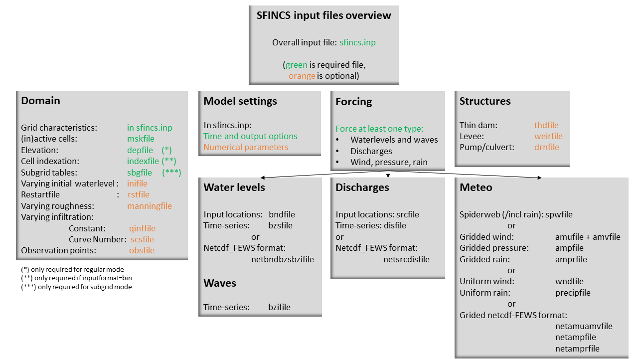
Fig. 22 Overview of input file of SFINCS with indication whther they are required or not
Domain
- sfincs.inp
- description
General input file of SFINCS describing all model settings, the domain, forcing and structures.
- required
yes
- format
asc
- depfile = sfincs.dep
- description
Elevation (bathymetry and topography) at grid cell centres above a reference level.
- units
m above reference level
- required
yes in case of regular mode, no in case of subgrid mode
- format
bin or asc
- mskfile = sfincs.msk
- description
This mask indicates for every cell whether it is an inactive cell (msk=0), active cell (msk=1), boundary cell (msk=2) or outflow boundary cell msk=3).
- units
- required
yes
- format
bin or asc
- indexfile = sfincs.ind
- description
File describing the indices of active grid cells within the overall grid. Not used by SFINCS with ascii input.
- units
- required
Only if ‘inputformat = bin’
- format
bin
- mskfile = sfincs.msk
- description
This mask indicates for every cell whether it is an inactive cell (msk=0), active cell (msk=1), water level boundary cell (msk=2) or outflow boundary cell msk=3).
- units
- required
yes
- format
bin or asc
- manningfile = sfincs.man
- description
For spatially varying friction values per cell use the manningfile option, with the same grid based input as the depfile using a binary file. Not used by SFINCS in subgrid mode.
- units
s/m^(1/3)
- required
no in case of regular mode, ignored in case of subgrid mode
- format
bin
- qinffile = sfincs.qinf
- description
For spatially varying constant in time infiltration values per cell use the qinffile option, with the same grid based input as the depfile using a binary file.
- units
mm/hr
- required
no
- format
bin
- scsfile = sfincs.scs
- description
For spatially varying infiltration values per cell using the Curve Number method A (without recovery) use the scsfile option, with the same grid based input as the depfile using a binary file.
- units
- required
no
- format
bin
- smaxfile = sfincs.smax
- description
For spatially varying infiltration values per cell using the Curve Number method B (with recovery) provide the smaxfile (as well as the sefffile and ksfile) as maximum soil moisture storage capacity in m, with the same grid based input as the depfile using a binary file.
- units
m
- required
no
- format
bin
- sefffile = sfincs.seff
- description
For spatially varying infiltration values per cell using the Curve Number method B (with recovery) provide the sefffile (as well as the smaxfile and ksfile) as soil moisture storage capacity at the start in m, with the same grid based input as the depfile using a binary file.
- units
m
- required
no
- format
bin
- ksfile = sfincs.ks
- description
For spatially varying infiltration values per cell using the Curve Number method B (with recovery) provide the ksfile (as well as the smaxfile and sefffile) as saturated hydraulic conductivity in mm/hr, with the same grid based input as the depfile using a binary file.
- description
For spatially varying infiltration values per cell using the Green & Ampt method (with recovery) provide the ksfile (as well as the sigmafile and psifile) as saturated hydraulic conductivity in mm/hr, with the same grid based input as the depfile using a binary file.
- units
mm/hr
- required
no
- format
bin
- sigmafile = sfincs.sigma
- description
For spatially varying infiltration values per cell using the Green & Ampt method (with recovery) provide the sigmafile (as well as the psifile and ksfile) as suction head at the wetting front in mm, with the same grid based input as the depfile using a binary file.
- units
mm
- required
no
- format
bin
- psifile = sfincs.psi
- description
For spatially varying infiltration values per cell using the Green & Ampt method (with recovery) provide the psifile (as well as the sigmafile and ksfile) as soil moisture deficit in [-], with the same grid based input as the depfile using a binary file.
- units
- required
no
- format
bin
- f0file = sfincs.f0
- description
For spatially varying infiltration values per cell using the Horton method (with recovery) provide the f0file (as well as the fcfile and kdfile) as maximum (Initial) Infiltration Capacity in mm/hr, with the same grid based input as the depfile using a binary file.
- units
mm/hr
- required
no
- format
bin
- fcfile = sfincs.fc
- description
For spatially varying infiltration values per cell using the Horton method (with recovery) provide the fcfile (as well as the f0file and kdfile) as Minimum (Asymptotic) Infiltration Rate in mm/hr, with the same grid based input as the depfile using a binary file.
- units
mm/hr
- required
no
- format
bin
- kdfile = sfincs.kd
- description
For spatially varying infiltration values per cell using the Horton method (with recovery) provide the kdfile (as well as the f0file and fcfile) as empirical constant (hr-1) of decay, with the same grid based input as the depfile using a binary file.
- units
hr-1
- required
no
- format
bin
- sbgfile = sfincs.sbg
- description
File containing subgrid tables, only needed by SFINCS if you want to run your model in the subgrid mode. Recommended netcdf file input option available from SFINCS 2024.01 release onwards as in Van Ormondt et al. 2024, binary file option still possible for backwards compatability.
- units
- required
Only for running SFINCS in subgrid mode
- format
new is netcdf, old is binary
- obsfile = sfincs.obs
- description
To get output time-series at individual point locations, observations points have to be specified.
- units
m in projected UTM zone
- required
no (only if point output is wanted)
- format
asc
- crsfile = sfincs.crs
- description
To get output time-series of discharge through a cross-section, cross_sections have to be specified.
- units
m in projected UTM zone
- required
no (only if cross-section output is wanted)
- format
tekal
- volfile = sfincs.vol
- description
Green infrastructure spatially varying storage volume in m3 per grid cell, with the same grid based input as the depfile using a binary file.
- units
m3
- required
no
- format
bin
- inifile = sfincs.ini
- description
For spatially varying initial water level per cell, with the same grid based input as the depfile using a binary file. In older version this was an ascii file still, not from official release v2.0.0 onwards!
- units
m above reference level
- required
no
- format
bin
- rstfile = sfincs.rst
- description
More advanced restartfile that can also contain fluxes and velocities. As produced by SFINCS if dtrstout > 0 OR trstout > 0. Type of restart - 1: zs, qx, qy, umean and vmean - 2: zs, qx, qy - 3: zs
- units
- required
no
- format
bin
Forcing - Water levels and waves
- bndfile = sfincs.bnd
- description
To specify water-level time-series to the boundary cells (msk=2), first the input locations have to be specified in ‘sfincs.bnd’.
- units
m in projected UTM zone
- required
Only when specifying water levels and waves.
- format
asc
- bzsfile = sfincs.bzs
- description
In the file ‘sfincs.bzs’ the (slowly varying) water level time-series are specified per input location.
- units
m above reference level
- required
Only when specifying water levels.
- format
asc
- bzifile = sfincs.bzi
- description
Tn the file ‘sfincs.bzi’ the quickly varying water level time-series due to incoming waves are specified per input location. Do note that the input timestep should be the same in both the bzs and bzi files!
- units
m around mean water level of bzsfile
- required
Only when specifying waves.
- format
asc
- netbndbzsbzifile = sfincs_netbndbzsbzifile.nc
- description
To specify all bnd, bzs (and bzi) input in 1 FEWS compatible netcdf input file. Specify either the netcdf version or ascii, not both.
- units
m in projected UTM zone, m above reference level & m around mean water level of bzsfile
- required
Only when specifying water levels and waves using netcdf input file.
- format
net
Forcing - Discharges
- srcfile = sfincs.src
- description
To specify discharge points, first the input locations have to be specified in ‘sfincs.src’.
- units
m in projected UTM zone
- required
Only when specifying discharges.
- format
asc
- disfile = sfincs.dis
- description
In the file ‘sfincs.dis’ the discharge time-series are specified per input location.
- units
m^3/s
- required
Only when specifying discharges.
- format
asc
- netsrcdisfile = sfincs_netsrcdisfile.nc
- description
To specify all src & dis input in 1 FEWS compatible netcdf input file. Specify either the netcdf version or ascii, not both.
- units
m in projected UTM zone, discharge in m3/s
- required
Only when specifying discharges.
- format
net
Forcing - Meteo
- spwfile = sfincs.spw
- description
Spiderweb file including wind speed, direction, pressure (and possibly rainfall).
- units
coordinates: m in projected UTM zone, data: m/s, wind_from_direction in degrees, p_drop in Pa (and precipitation in mm/hr).
- required
no
- format
asc
- netspwfile = spiderweb.nc
- description
Spiderweb file including wind speed, direction, pressure (and possibly rainfall).
- units
coordinates: m in projected UTM zone, data: m/s, wind_from_direction in degrees, p_drop in Pa (and precipitation in mm/hr).
- required
no
- format
netcdf
- amufile = sfincs.amu
- description
Delft3D-meteo ascii type input of wind speed in x-direction.
- units
coordinates: m in projected UTM zone, data: m/s
- required
no
- format
asc
- amvfile = sfincs.amv
- description
Delft3D-meteo ascii type input of wind speed in y-direction.
- units
coordinates: m in projected UTM zone, data: m/s
- required
no
- format
asc
- ampfile = sfincs.amp
- description
Delft3D-meteo ascii type input of atmospheric pressure.
- units
coordinates: m in projected UTM zone, data: Pa
- required
no
- format
asc
- amprfile = sfincs.ampr
- description
Delft3D-meteo ascii type input of precipitation intensity.
- units
coordinates: m in projected UTM zone, data: mm/hr
- required
no
- format
asc
- wndfile = sfincs.wnd
- description
Spatially uniform wind
- units
wind speed in m/s, wind direction in nautical from where the wind is coming
- required
no
- format
asc
- precipfile = sfincs.prcp
- description
Spatially uniform precipitation
- units
mm/hr
- required
no
- format
asc
- netamuamvfile = sfincs_netamuamvfile.nc
- description
FEWS type netcdf meteo input with wind speed in both x-&y-direction in m/s.
- units
coordinates: m in projected UTM zone, data: m/s
- required
no
- format
net
- netampfile = sfincs_netampfile.nc
- description
FEWS type netcdf meteo input with atmospheric pressure in Pa.
- units
coordinates: m in projected UTM zone, data: Pa
- required
no
- format
net
- netamprfile = sfincs_netamprfile.nc
- description
FEWS type netcdf meteo input with precipitation in mm/hr.
- units
coordinates: m in projected UTM zone, data: mm/hr
- required
no
- format
net
Structures
- thdfile = sfincs.thd
- description
With a thin dam flow through certain grid cells is completely blocked (i.e. an infinitely high wall).
- units
coordinates: m in projected UTM zone.
- required
no
- format
asc
- weirfile = sfincs.weir
- description
Weirs are in principle the same as a thin dam, but then with a certain height (levee).
- units
coordinates: m in projected UTM zone, elevation in m above reference level, weir formula coefficient in [-]
- required
no
- format
asc
- drnfile = sfincs.drn
- description
Drainage pumps, culverts and check valves are both specified using the same format file, put with a different indication of the type (type=1 is drainage pump, type=2 is culvert and type=3 is check valve).
- units
coordinates: m in projected UTM zone, discharges in m^3/s.
- required
no
- format
asc